Key Takeaways
Here are the facts to know about the Houston region this month
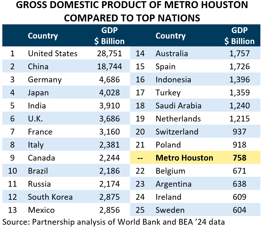
#1 - Houston is home to one of the largest most diverse economies in the nation. Key industries like health care, professional and technical services, manufacturing, energy, and aerospace/aviation help make the region’s economy larger than countries like Belgium, Argentina, Sweden or Ireland.
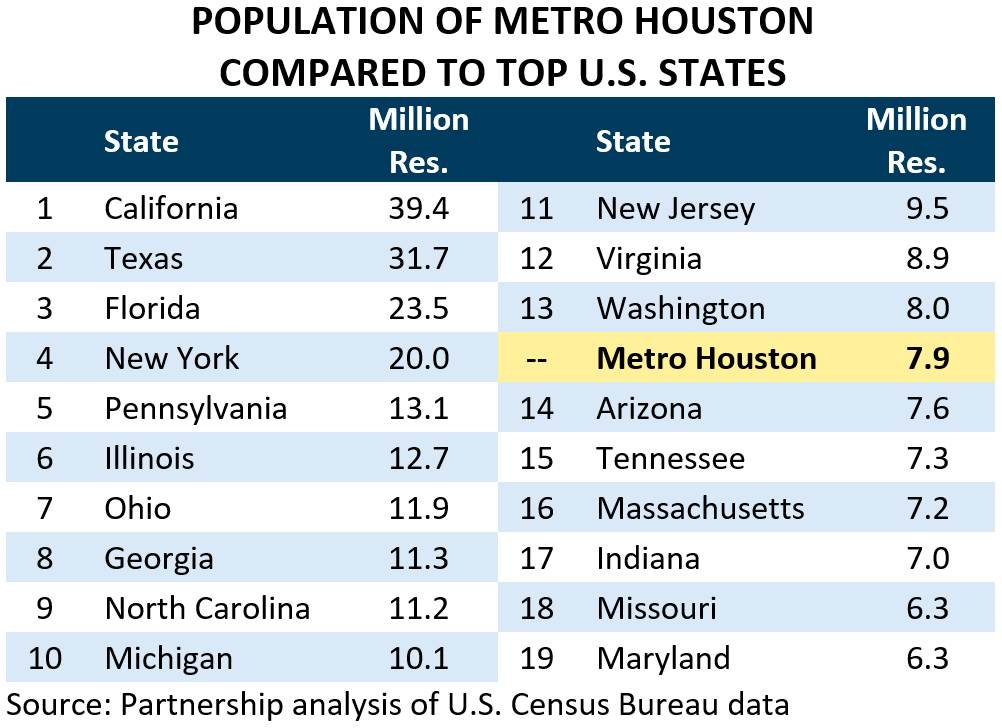
#2 - Spanning 8,839 square miles of land, the Houston region is home to 7.9 million people. If it were an independent state it would be the 14th largest in the country ahead of states like Arizona or Tennessee.
#3 - Houston leads the nation in base petrochemical production, accounting for 41.1 percent of the nation’s overall capacity.
HOUSTON FACTS
On August 5th, the Greater Houston Partnership released its Houston Facts ‘26 report. The full report can be found at the Partnership’s website. Highlights from the report are found below:
Geography
Metro Houston (known formally as the Houston-Pasadena-The Woodlands Metropolitan Statistical Area by the U.S. Census Bureau) consists of the following 10 counties:
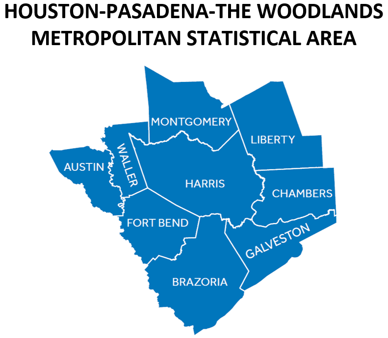
The region spans 8,839 square miles of land, making it larger than the U.S. states like Massachusetts, New Jersey and Hawaii. It includes 128 separate cities and 37 census-designated places.
Demographics
The region’s population is even more impressive than its land mass. As of July ’25, it is home to approximately 7.9 million people, making it the fifth-largest U.S. metro behind New York, Los Angeles, Chicago, and Dallas/Fort Worth. If it were an independent state, it would be the 14th largest in the country, with a population slightly smaller than Washington but larger than Arizona, Tennessee, or Massachusetts.
The population has been growing rapidly, adding 754,400 new residents since the start of the decade (April ’20 to July ’25). International migration accounts for the majority (51.2 percent) of these new residents, while domestic migration and natural population change (i.e. the number of babies born minus the number of people who die) account for 18.4 and 30.4 percent, respectively.
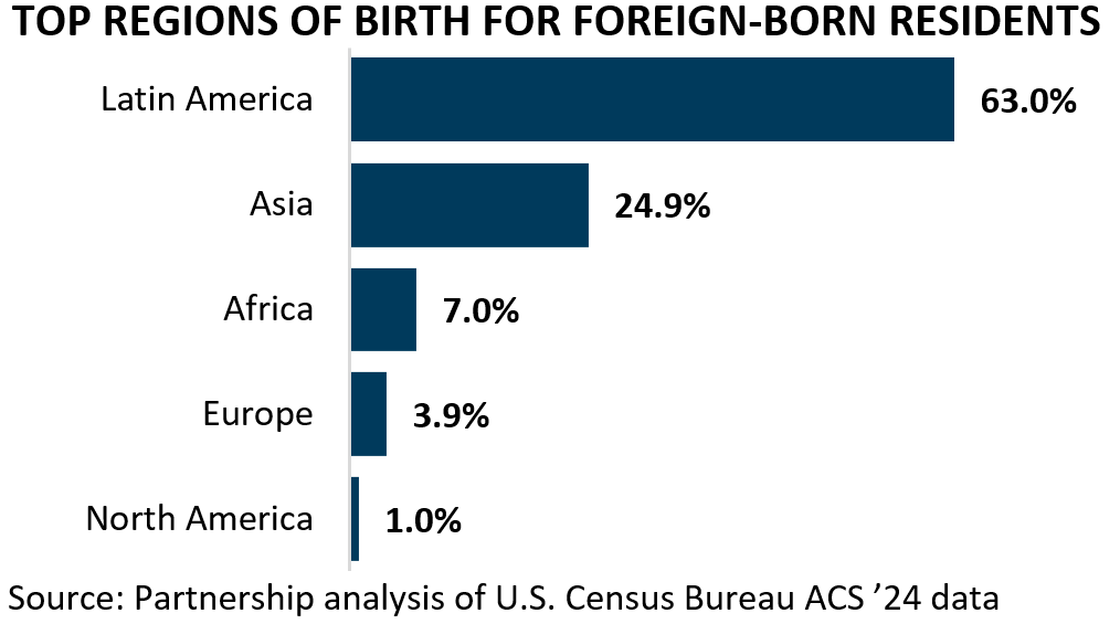
Nearly 2.0 million Houstonians (or roughly one-in-four) were born outside the U.S. Since Houston is so close to Latin America, it should be no surprise that the majority (63.0 percent) were born in that region. But significant swaths were also born in Asia, Africa, Europe, and North America.
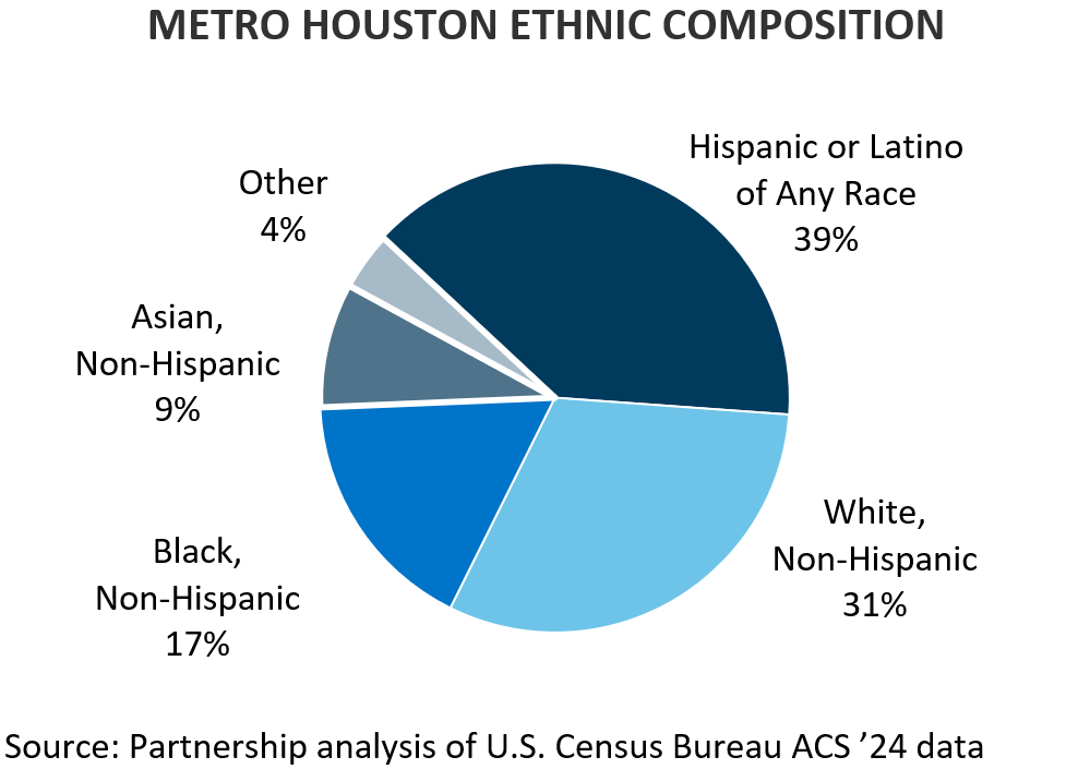
Metro Houston is one of the most ethnically diverse places in the United States, with no single ethnic group representing a majority. The largest ethnic groups are Hispanics or Latinos of any race, White non-Hispanic, Black non-Hispanic, and Asian non-Hispanic.
Economy
Houston’s economy remains one of the largest and most diverse in the nation. The value of all goods and services produced in metro Houston was valued at $758 billion in ’24. That is more than the value produced by most countries across the globe. In fact, if the region were an independent country, it would have the 22nd most valuable economy in the world, behind Switzerland and Poland, but ahead of countries like Belgium, Argentina, Ireland, and Sweden.
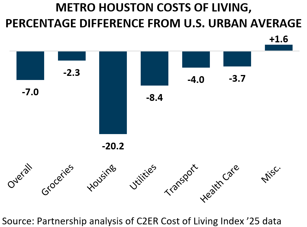
Per-capita personal income in the region was $76,916 in ’24, approximately $3,712 higher than the national average. This suggests that the average Houstonian earns more than the average American – but that only tells part of the story. Among the 20 most populous U.S. metros, Houston is the 3rd most affordable according to the ’25 C2ER Cost of Living Index, with an overall cost of living that is 7.0 percent below the U.S. urban average. The region’s housing, utility, and transportation costs are also significantly lower than those found elsewhere in the country. This means that not only do Houstonians earn more, but their dollars go further.
Note: The geographic area referred to in this publication as “Houston,” "Houston Area” and “Metro Houston” is the ten-county Census designated metropolitan statistical area of Houston-Pasadena-The Woodlands-Sugar Land, TX. The ten counties are: Austin, Brazoria, Chambers, Fort Bend, Galveston, Harris, Liberty, Montgomery, San Jacinto, and Waller.
To continue reading, please download the full report below: